C1. Title and statement of responsibility area
C1.1. General rule
Plan of the city of Washington in the territory of Columbia
Bib/image: http://memory.loc.gov/cgi-bin/query/r?ammem/gmd:@field(NUMBER+@band(g3850+ct000299))
Status: Used 12/13/13
Atlas novus indicibus instructus, oder, Neuer mit Wort-Registern versehener Atlas
Bib: http://hdl.handle.net/10079/bibid/589762
Image: http://kramerius4.mzk.cz/search/i.jsp?pid=uuid:844c421a-82e0-11e0-bc9f-0050569d679d&q=atlas
Status: Used 12/13/13 (also used in 1B4.2)
Carte de la partie françoise de St. Domingue = A map of the French part of St. Domingo
Image: http://www.davidrumsey.com/luna/servlet/s/okl0y0
Status: Used 12/13/13 (also used in 1D2.1)
Map of Chili ; Map of Brazil, Bolivia, Paraguay, and Uruguay
Image: http://memory.loc.gov/cgi-bin/query/r?ammem/gmd:@filreq%28@field%28NUMBER+@band%28g5400+br000024%29%29+@field%28COLLID+gnrlmap%29%29
Status: Used 12/13/13 (also used in 1G1.1)
C1.2. Titles preceded by grammatically inseparable statements of responsibility
Bancroft's map of the Washoe silver region of Nevada Territory
Image: http://hdl.huntington.org/cdm/ref/collection/p15150coll4/id/3476
Bib: http://hdl.handle.net/10079/bibid/5982976
Status: Used 12/13/13
Claudii Ptolemaei Alexandrini Geographicae enarrationis libri octo
Bib record: http://josiah.brown.edu/record=b4634682~S7
Image: http://books.google.com/books?id=Ow5QAAAAcAAJ&pg=PA34&source=gbs_selected_pages&cad=3#v=onepage&q&f=false
Status: Used 12/13/13 (also used in 1B2.1)
MT: Changed capitalization of "Geographicae" to lower case. 9/9/14
C1.3. Grammatically independent titles of supplements and sections
The English pilot. The fourth book
Image: http://www.maphist.com/artman/publish/ThorntonSeller.html
Status: Used 12/13/13 (also used in 1B7)
C1.4. General material designation
[cartographic material]
[cartographic material (tactile)]
C1.5. Other title information
: being a new set of county maps from actual surveys ...
http://books.google.com/books?id=TgfXCDXhyGsC&printsec=frontcover&source=gbs_ge_summary_r&cad=0#v=onepage&q&f=false
Status: Used 12/13/13
: ein neuer Atlas in 100 Kartenseiten mit statistischen Angaben und alphabetischem Namensverzeichnis
http://catalog.nypl.org/record=b13945151~S1
Status: Used 12/13/13
C1.6. Statement of responsibility
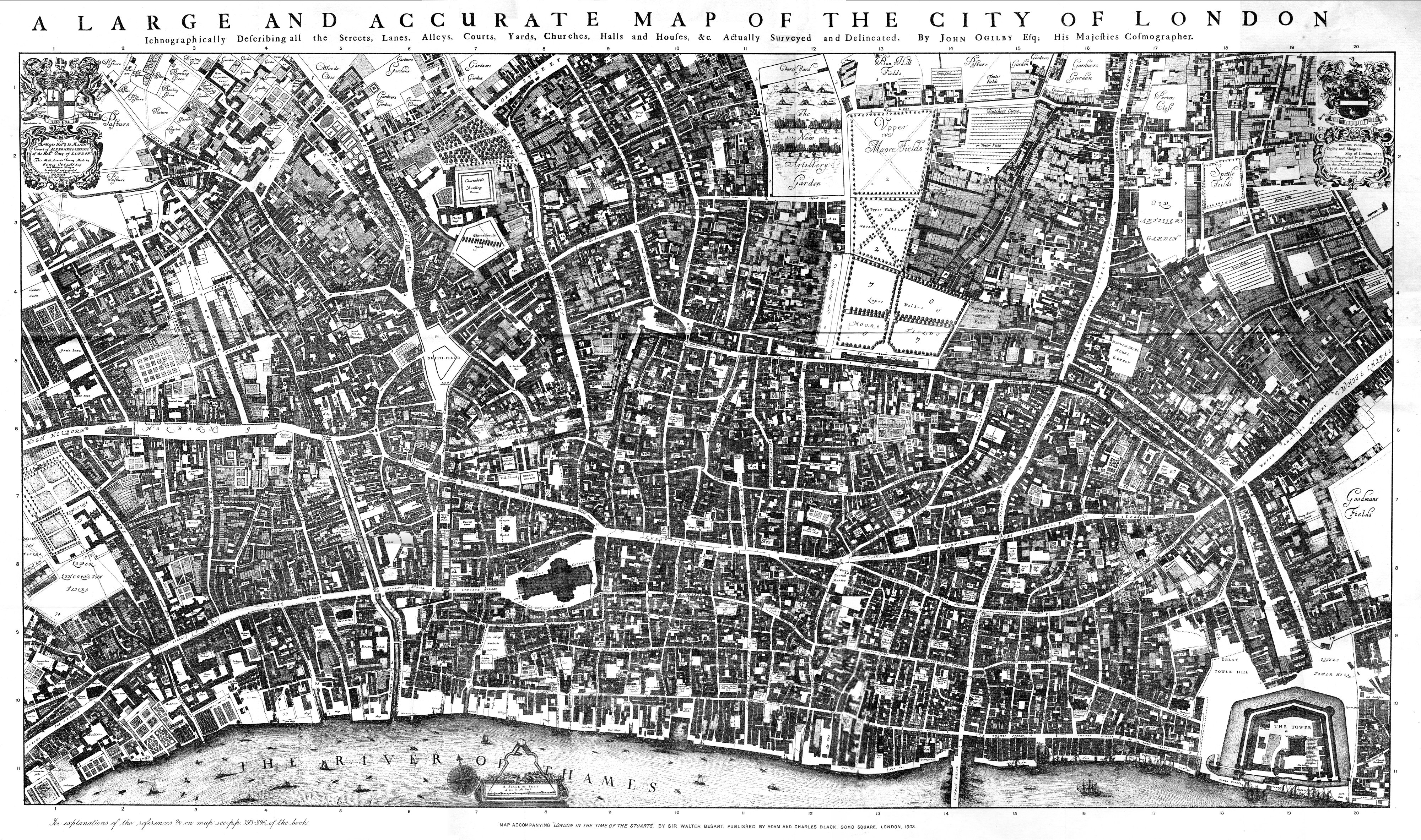
/ actually surveyed and delineated by John Ogilby, Esq., His Majesties cosmographer
Bib: http://hdl.handle.net/10079/bibid/584294
Image: http://upload.wikimedia.org/wikipedia/commons/6/63/City_of_London_Ogilby_and_Morgan%27s_Map_of_1677.jpg
Status: Used 12/13/13 (also used in 1F2)
/ par le Sr. Robert, géographe
Bib: http://hdl.handle.net/10079/bibid/8204507
Image: http://maps.library.yale.edu/images/public/3371_1754_Hainaut_recto.jp2
Status: Used 12/13/13 (also used in 1F8)
/ by the late Reverend Mr. John Flamsteed, religious professor of astronomy at Greenwich
Image: http://library.queensu.ca/webmus/sc/flamsteed.jpg
Status: Used 12/13/13 (also used in 1F8)
/ dessiné & gravé sous la direction de l'Academie imperiale des sciences & des arts
http://lccn.loc.gov/14002124
http://hdl.loc.gov/loc.gmd/g7064lm.gct00144
Status: Used 12/13/13 (also used in 1F11.2)
C2. Edition area
The second edition
Image: http://images.library.yale.edu/shimages/sh-000525.jpg
Status: Used 12/13/13 (also used in 2B2.1)
Ausgabe in 100 Blättern
Image: http://www.atlassen.info/atlassen/flemming/sohha06/picslarge/sohha1874a301.jpg
Status: Used 12/13/13 (also used in 2B2.1)
[State 1]
Status: Used 12/13/13 (made up; also used in 2B5.1, alternative rule]
The second edition, Reprinted with a new preface
Status: Used 12/13/13 (made up; also used in 2D1)
Corrigée et augmentée en 1780 / par J.N. Buache, géog. ord. du roi
Bib. record: http://hdl.handle.net/10079/bibid/10202408
Image
Status: Used 12/13/13 (also used in 2C1.1)
C3. Mathematical details area
Scale 1:500,000
Status: Used 12/13/13 (also used in 3B1.1)
Scale 1:250,000. Vertical scale 1:25,000. Vertical exaggeration 10:1
Status: Used 12/13/13 (also used in 3B5.1)
; transverse Mercator proj., central meridian 35°13′30″E
Status: Used 12/13/13 (also used in 3C1.3)
C4. Publication, distribution, etc., area
C4.1. General rule
1st paragraph:
: Chez P. Duménil, éditeur, rue des Beaux-Arts, 10
Image: http://www.davidrumsey.com/luna/servlet/s/28nz5w
Status: Used 12/13/13 (also used in 4C2)
: Published by W. Faden, geographer to the King & to H.R.H. the Prince of Wales, Charing Cross ; Dublin : Sold by W. Allen & J. Archer
Bib
Image
Status: Used 12/13/13 (also used in 4A6.1)
: Chez C. Mortier & J. Covens et fils
http://digitalcollections.nypl.org/items/510d47db-c6b5-a3d9-e040-e00a18064a99
Status: Used 12/13/13
London : Published by Baldwin & Cradock, 47 Paternoster Row, Decr. 15th, 1832 ([London] : Printed by E. Brain, Bartholomew Close)
Bib: http://oskicat.berkeley.edu/record=b15923686~S60
Image: http://www.davidrumsey.com/luna/servlet/s/palotd
Status: Used 12/13/13 (also used in 4E2)
These were all accepted "as is" from the general chapter draft produced by the DCRM Steering Committee:
In Venetia
Den Haag but s'-Gravenhage
Gedruckt zu Franckfort am Mayn
[S.l.] : [s.n.]
2nd paragraph:
These were all accepted "as is" from the general chapter draft produced by the DCRM Steering Committee:
, printed in the year MDCLXXXIX [1689]
, an sixième de la République [1798?]
, anno Domini Mdiij [1503]
, im Jahr 1715
C4.2. Addresses and signs in publisher, distributor, manufacturer, etc., statements
: Sold by William Berry at the sign of the Globe between Charing-Cross and White-Hall
http://neworbexpress.library.yale.edu/vwebv/holdingsInfo?bibId=8474977
Status: Used 12/13/13 (also used in 4C2)
: Printed and given out at Amsteldam by Nicolas Visscher upon the Dam at the signe of the Fisher and are to be sould at London by Iohn Overton at the White Horse without Newgate
Bib. record: http://neworbexpress.library.yale.edu/vwebv/holdingsInfo?bibId=9737012
Image: http://www.swaen.com/zoomamo.php?id=13657 [imprint in lower right corner]
Status: Used 12/13/13 (also used in 4A6.3.1)
C5. Physical description area
These were made up:
1 atlas (XLI, [3], 276 p., [12] leaves of plates)
4 maps on 1 sheet : col. ; each 22 x 28 cm, sheet 50 x 72 cm
ca. 100 maps
: 2 col. ill. (Baxter prints), 72 col. maps
C6. Series area
C6.1. General rule
(Walker's county maps)
Bibliographic record: http://oskicat.berkeley.edu/record=b18347582~S1
Status: Used 12/12/13 (also used in 6A2.2)
C6.2. Terms used in conjunction with numbering
(Publication no. 12 of the Sierra Club)
Bibliographic record: http://oskicat.berkeley.edu/record=b10981004~S1
Status: Used 12/13/13 (also used in 6B2)
(Transactions / American Philosophical Society ; vol. I, new series)
Image: http://www.davidrumsey.com/luna/servlet/s/fn9jsl
Status: Used 12/12/13 (also used in 6H2)
C8. Standard number and terms of availability area
ISBN 1-585460-22-2
Status: Used 12/13/13 (also used in 8B1)
ISBN 83-62622-07-5 (set). -- ISBN 83-62622-08-3 (v. 1). -- ISBN 83-62622-09-1 (v. 2)
Bib: http://lccn.loc.gov/2012381099
Status: Used 12/13/13 (also used in 8B2)
Comments (0)
You don't have permission to comment on this page.